「韓国-日本間の海」という説明も
The Chosun ilbo reported there are the description of "Sea of Corea " on the attached map of The Universal Gazzetter ,published on 1760. London.
checking various Gazetter, there are many Sea of Japan gazetter in the world and this report is rare case, i think.
http://seaofjapan-noeastsea.blogspot.com/2008/12/index-for-sea-of-japan-no-east-sea.html
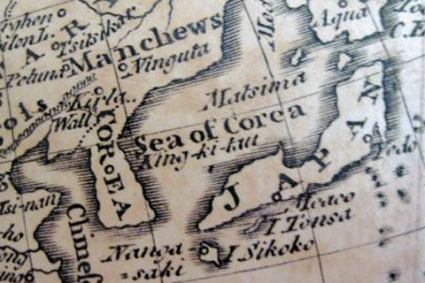
【全炳根(チョン・ビョングン)記者】 18世紀半ばにイギリスで出版された世界地名辞典で、東海(日本名:日本海)を「韓国海(Sea of Corea)」と表記した地図が初公開された。1760年にロンドンで初めて発行された「世界地名辞典(The Universal Gazetteer)」に収録されている世界地図=写真=には「東海」が「韓国海(Sea of Corea)」と書かれており、別途に「アジアの主な海・湾」を紹介している項目には「韓国海(Corean Sea)」を「韓国(Corea)と日本の島々の間にある」と具体的な位置も明記されている。当時の大英帝国は各国の地名の世界的標準化が必要だと判断、 全世界に探検家らを送り、資料を収集していた。
「東海フォーラム」会長キム・シン慶煕大教授は「以前、西洋で発見された古地図に『韓国海』または『東海』と表記されていたケースはあったが、権 威あるイギリスの世界地名辞典が東海を『Corean Sea』とし、地理的な定義・位置まで明確に書いたような資料が確認されたのは初めて」と話す。東北アジア歴史財団のチャン・ドンヒ国際表記名称大使は 「東海の表記をめぐり、国際的な交渉が続いている状況で、わたしたちがこれまで一貫して主張してきた『19世紀以前には韓国海という表記が優勢だった』と いう論理を補強する資料として意味がある」と述べた。
この地名辞典は、10-17日に国立中央図書館で開催される東海フォーラム主催の展示会「失われた韓国海を探して」で一般公開される。展示会には このほかにも1768年にイギリス・スコットランドで出版されたブリタニカ百科事典初版本をはじめ、東海表記関連古地図・書籍など100点余りが公開され る。
また、英語版では
Archaic British Gazette Undermines Japan's Claim to 'East Sea'
The East Sea was described as the "Sea of Corea" in a map of the world published by "The Universal Gazetteer," which was first released in London in 1760. In a separate chapter that introduces the major seas and gulfs of Asia, the gazetteer specifies that the "Corean Sea" lies between "Corea" and the Japanese islands.
The 530-page gazetteer, which includes seven maps of the world, accurately describes Korea's geographical location. It states that the country lies at between 35 degrees and 43 degrees north latitude, and between 126 degrees and 136 degrees east longitude.
との話です。原本をまだ確認していませんが、”1760年にロンドンで初めて発行された「世界地名辞典(The Universal Gazetteer)」”いづれ探そうかと思いますが、同名の本は、いろいろな出版社がだしているので、どれか特定する必要はありますが・・・。
1760年あたりのの地名時点関係ですと、私はThe general gazetteer, or, Compendious geographical dictionary : (1762)をすでに昨年発見しています。
http://seaofjapan-noeastsea.blogspot.com/2010/09/1762the-general-gazetteer-or_08.html
![]() 確かにこれは地図にはSea of Koreaが書いてあるのですが、実は、中の文章を見ると見事にSea of Japanが書いてあるものなのです。
確かにこれは地図にはSea of Koreaが書いてあるのですが、実は、中の文章を見ると見事にSea of Japanが書いてあるものなのです。
よって、この1760年のものも、添付地図ではなく、中になんと書いてあるのか、読んでみたいものです。
そして、ちと同じ会社のものであるのかはわかりかねますが、
New Universal Gazetterの1823年版をみてみると、見事に、Sea of Japan が文章説明の中に書いてあります。こういうオチがあるのです。
http://seaofjapan-noeastsea.blogspot.com/2011/08/1823a-new-universal-gazetteer-or.html
http://www.archive.org/stream/anewuniversalga00morsgoog#page/n200/mode/2up/search/japan
Corea, a large country of Asia, E. of China and consisting of a penunsula, formed on on side by the Yellow Sea , ad on the other by the sea of Japan, 400 miles long, and 150 broad. Very little is known to Europeans about this country. The king pays tribute to the emperror of China; and in manners, religion, and written language, the people resembles the Chiese. The spoken dialect is entirely different. The same jealousy of foreign intercourse exists as in China and Japan.
La Perouseなどが日本海(Mar du Japon)と朝鮮海峡(Detoit de coree)を通過し、その航海と地図が世に知られるようになって、一時期地図に記載されていた朝鮮海(Korean sea)などは地図から消えていくことになります。このようにして日本海の世界標準化が起こりました。
*2011/08/12 追記
今まで貯めておいたGatteerr類を整理してみました。やはりほとんど日本海表記でした。
http://seaofjapan-noeastsea.blogspot.com/2011/08/most-of-gazetters-draws-sea-of-japan.html追記ここまで
それにしても、この程度の”発見”で記事になるのならば・・私のBlogは韓国では年中記事になってしまいます・・・。韓国人の歴史歪曲による不謹慎な願望を打ち砕く材料としての


0 件のコメント:
コメントを投稿